India’s seasonal calendar has a tragic twist of fate. The southwest monsoon comes in from the Arabian Sea and the Bay of Bengal every June. It brings with it the promise of life: water for crops, relief from the scorching pre-monsoon heat, and rivers that feed hundreds of millions of people. But every year, that same monsoon brings something far more confusing: it floods one half of the country while the other half begs for rain. Farmers in Rajasthan and Vidarbha look at the cracked ground and pray. In Assam and Bihar, brown floodwater covers whole villages. Clouds don’t care about what people need. But they do discriminate based on where you live, and more and more, based on the strange new logic of a warming planet.
This isn’t just a story about how rain falls unevenly; that’s part of it. It tells the story of a country whose infrastructure was built for a monsoon that no longer acts the way it used to, whose water policies have failed to close the gap between too much and too little, and whose most vulnerable groups—farmers, fisherfolk, and tribal communities—are paying the price for both extremes at the same time.
—
The monsoon is not just one thing; it is many.
First, you need to get rid of the idea that the Indian monsoon is one big meteorological event. This will help you understand why Rajasthan is dry while Kerala and Assam are flooded. The southwest monsoon actually comes in two parts: one moves from the Bay of Bengal to the northeast, and the other moves along the Arabian Sea coast into western India. These branches run at different speeds, carry varying amounts of moisture, and work with quite different types of land. The Western Ghats are like a huge wall that makes rainfall from the Arabian Sea climb, chill, and fall on the windward shore. This leaves the rain-shadow areas of Karnataka and Maharashtra dry. The Himalayas keep precipitation from the Bay of Bengal in the northeast, which makes Meghalaya the wettest region on Earth. Meanwhile, districts barely 200 kilometers to the west are having trouble getting enough water.
In certain regions of Rajasthan, the annual rainfall is less than 100 mm, whereas in Mawsynram, Meghalaya, it is more than 11,000 mm. This is all theoretically part of the same “monsoon season.” This difference in geography has always been there. The 21st century has seen changes in its strength and unpredictability.
Data from the India Meteorological Department (IMD) and other climate researchers show a very worrying trend: the monsoon is not just bringing the same amount of rain to different places; it is bringing shorter, sharper, and more extreme bursts of rain while also making the dry spells between those bursts longer. Between 1950 and 2015, central India saw a 75% rise in extreme rainfall events that dropped more than 150 mm in a single day. At the same time, dry spells during the monsoon season have gone up by 27% from 1981 to 2011 compared to the baseline period of 1951 to 1980. In many places, almost half of all seasonal rainfall now falls in just 20 to 30 hours. This makes dry intervals that can kill crops that have only just started to grow.
In real life, this implies that a district that officially records “normal” rainfall for the season may have gotten it all in three terrible storms, leaving crops either dead or wilting in the weeks between storms.
—
The Drought Belt: Rajasthan, Gujarat, and the Pain of Vidarbha
Drought is not unusual in the states of Rajasthan, Gujarat, and Vidarbha, which lies in the eastern part of Maharashtra. It happens often in life, and climate change is making it worse and more common.
Rajasthan has mostly dry and semi-arid country that covers more than 340,000 square kilometers. In the past, it hasn’t gotten much rain during the monsoon season. The Thar Desert, which covers the western part of the country, gets only 50 to 100 mm of rain a year. Because they had to be creative to survive when resources were scarce, traditional Rajasthani communities built complex indigenous water collecting methods over hundreds of years. These include johads (earthen check dams), baoris (stepwells), and taaankas (underground cisterns). These systems are mostly broken down now because they were neglected and because piped water projects only reached some regions and left others behind.
The tale of Vidarbha is about cotton, debt, and hopelessness. For the past twenty years, this part of Maharashtra has been at the center of India’s agricultural crisis. It is made up of twelve districts. Rain-fed cotton farming is very important to the area’s economy. When the monsoon doesn’t come or comes at strange times, cotton yields drop, debts rise, and farmer suicides, a sad reflection of the region’s suffering, go up. In 2023, Maharashtra officially declared drought in 66% of its administrative regions since the monsoon brought less than 75% of the state’s usual rainfall. But in the same year, flash floods hit the coastal and ghat districts of the same state, killing dozens of people and damaging infrastructure.
Gujarat is probably the best example of the paradox of simultaneous extremes. The state had almost 30% less rain in June 2024 than it normally does. But by September, it had gotten 118% of its typical amount, which caused terrible floods that displaced tens of thousands of people. The rain that came didn’t last for weeks. It came in huge, destructive bursts from a stronger moisture corridor in the Arabian Sea, flooding drainage systems and reservoirs that weren’t built to handle so large amounts of water in such a short amount of time.
—
The Flood Zones: Coastal Odisha’s Broken Levees, Assam, and Bihar
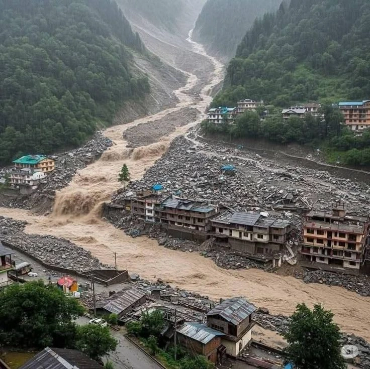
Drought is like a lingering death from thirst, whereas flooding in the Brahmaputra plains of Assam is like a violent, yearly drowning. The Brahmaputra is one of the biggest rivers in the world by volume. It flows through the narrow Assam valley, bringing glacier melt and monsoon rain from the Tibetan Plateau. When the monsoon is strong or when cloudbursts in the upper catchment area bring months of rain in just a few days, the Brahmaputra and its tributaries overflow their banks with such force that they change the landscape.
The floods of June and July 2024 wreaked havoc across Assam, obliterating over 1,325 villages spread across 19 districts. The disaster claimed 109 lives and displaced upwards of 400,000 individuals from their residences.
The Kopili, Barak, and Kushiyara rivers all flooded at the same time, causing a flood that no emergency response system could stop. Floodwaters even covered Kaziranga National Park and Tiger Reserve, which is home to two-thirds of the world’s one-horned rhinoceroses. More than 200 wild creatures, including ten endangered rhinos, died in the floods.
Bihar, which is where rivers from Nepal’s hills meet, is seeing a different but equally terrible pattern. The northern parts of the state are some of the most flood-prone in the world. They get water not just from local rain but also from cloudbursts in the Himalayan foothills that are hundreds of kilometers distant. In many places, embankments that were erected during colonial times and expanded after independence have made the issue worse. By keeping rivers in narrower channels, they have elevated the levels of the riverbeds over the years. This means that any breach would be far worse than it would have been on a natural floodplain. Flooding in July 2024 killed 54 people and affected 1.8 million people in 923 villages in Uttar Pradesh alone. This state is located in the transition zone between India’s drought belt and its flood-prone north.
Coastal Odisha is at risk of flooding in a third way: when cyclones cause flooding along the coast and heavy rain falls inland. The state is in the Bay of Bengal’s most active cyclone corridor. When a depression or cyclone hits at the same time as the peak monsoon flow, rivers break through their banks and the sea moves inland at the same time. The Hirakud Dam, which is one of the biggest earthen dams in the world, was created to control the Mahanadi River and keep the coast of Odisha safe. But Hirakud was built to handle a mid-20th century monsoon. As significant rain events become more often and unpredictable, the dam has to choose between retaining water, which could put stress on the structure, or letting it go all at once, which would cause another disaster downstream.
—
Why India Can’t Keep the Rain It Gets
This might be the biggest policy failure in modern Indian government: not being able to store and move the extra water from the monsoon to areas that need it, even though both calamities happen in the same country, often in the same month.
India gets about 4,000 billion cubic meters of rain every year. Only a small amount of this water gets to useable reservoirs and aquifers. The rest goes into rivers and then to the ocean, taking with it not just water but also topsoil, nutrients for crops, and the food security of future harvests.
The issue is both structural and systemic. India’s main network of reservoirs was built mostly between the 1950s and the 1980s. It was based on old patterns of rainfall and population distribution that have altered a lot since then. Canal systems that were supposed to move water from river basins with too much water to agricultural areas with too little water have been poorly maintained for decades, have built up sediment, and have been split up by rival state governments. The well-known water disputes between states, such the one between Karnataka and Tamil Nadu over the Cauvery and the one between Punjab, Haryana, and Rajasthan over the Ravi-Beas waters, have stopped efforts to join rivers and agreements to share water between regions for decades.
Rainwater collecting used to be the main way India kept its water safe without having to build big infrastructure projects. Now, though, it has mostly been abandoned in favor of these projects. Many states have rules that require rooftop rainwater collecting, but execution has been patchy at best and non-existent at worst. Tamil Nadu declared it mandatory for all buildings as far back as 2001, and similar regulations exist in Rajasthan, Karnataka, Maharashtra, and Gujarat. Urban housing societies see rainwater collecting infrastructure as a burden to follow the rules, not as something they need. Rural areas don’t have the administrative resources to enforce building rules, therefore conventional water conservation structures aren’t used anymore.
The figures make it clear what happened because of this storage failure. India is now the world’s biggest user of groundwater, taking 25% of all groundwater used around the world. Even if the monsoon rains are flooding Assam, the water tables in Rajasthan and parts of Punjab have been going down for years. In some regions, the country is drowning in too much water, while in others, it is running out of its underground supplies.
—
Climate Change: The Thing That Makes Extremes Worse
It’s not new that India’s flood zones and drought belts are different. But climate change has made both sides of this equation louder in ways that are becoming more and more well-known.
According to research published in peer-reviewed publications and backed up by IMD’s own datasets, the average amount of rain that falls during the southwest monsoon has dropped by 0.5 to 1.5 mm per day every decade over the Indo-Gangetic plains and northeast India from 1951 to 2024. Meanwhile, areas of northwestern India that have been dry in the past, such North Karnataka, Maharashtra, and even parts of Rajasthan, have seen more rain during certain times of the year. This change in the way moisture moves around makes it harder to plan for farming, build infrastructure, and get ready for disasters that have been in place for generations.
The most concerning discovery is that even El Niño years, which are usually linked to drought in India, are no longer completely dry. A study published in the journal Science in 2025 found that El Niño conditions tend to lower the total amount of monsoon rain, but they also make intense single-day rain events more common in heavily populated areas of central India. That means that drought and heavy rain can happen at the same time, not just in different states but also in the same district during the same season.
Since 1997, the area of India that is prone to drought has grown by 57%. Since 2012, the number of times it rains heavily has grown by over 85%. Urban flooding alone costs around four billion dollars a year. If existing land use and infrastructure patterns stay the same, this number might grow to thirty billion dollars by 2070. Between April and July 2025, weather extremes destroyed crops on more over 1.58 lakh hectares in 13 states.
This story is all about the Indian Ocean getting warmer. Monsoon circulation systems get more moisture and energy from higher sea-surface temperatures. This makes low-pressure systems and depressions in the Bay of Bengal stronger. When these systems hit land, they provide rain that would have been called a 100-year or even 200-year event by criteria from the middle of the 20th century. But now they come with worrying regularity. During the 2024 monsoon, a trifecta of floods struck within a span of three days, each with a return period of 75, 100, and 200 years.
The human cost of this disaster is measured in more than just statistics. In Bihar, for instance, men are abandoning their inundated family homes, seeking employment opportunities in Punjab and Delhi.
Women and children stay in displacement camps, which puts a burden on already weak urban infrastructure and breaks up families. A cotton farmer in Vidarbha is seeing her third failing crop in a row and is thinking about a debt that she will never be able to pay back. In Assam, a rhino keeper wades chest-deep through floodwater to get to animals that are stuck in a wildlife reserve that was given safety by dams erected fifty years ago.
Scientists, hydrologists, and climate policy specialists all know what the solutions are, even though they aren’t easy. Reviving and modernizing traditional structures like johads, taaankas, and check dams on a large scale might help vulnerable areas deal with both floods and droughts. Reforming the infrastructure for canal irrigation to cut down on the 40% to 60% of water that is wasted to seepage and evaporation in current systems will make any rain that does fall far more useful. It is important for governments to change the rules for sharing water between states so that they can manage the monsoon over the entire basin instead of just taking it from one state at a time. And adding real-time satellite-based rainfall monitoring to district-level disaster preparedness might save thousands of lives and billions of rupees every season by changing from reactive flood relief to proactive flood routing.
You don’t have to wait for the monsoon to change for any of this to happen. It will rain. India needs to decide if it will stay a country that floods and is thirsty at the same time, or if it will finally learn to keep and share what the sky gives.
—
**Important Points to Remember:
– The southwest monsoon in India is not the same in all states; it brings both extremely large and very small amounts of rain at the same time.
– Drought-stricken areas in Rajasthan, Gujarat, and Vidarbha are getting drier even in years when the country as a whole gets ordinary amounts of rain.
– The Brahmaputra, Himalayan rivers, and Bay of Bengal cyclone-linked systems cause annual flooding in areas that are prone to flooding, such as Assam, Bihar, and coastal Odisha.
– India’s inability to store extra monsoon water because of broken reservoirs, failing rainwater harvesting systems, and water disputes between states makes both problems worse.
– Since 2000, climate change has made both extremes worse: there have been 75% more extreme rainfall occurrences in central India since 1950, while drought-prone areas have grown by 57% since 1997.
– India needs to make big changes to how it stores water, manages canals, and governs its whole basin if it wants to stop having floods and droughts at the same time every year.
—
*SEO Keywords: Indian monsoon drought flood paradox, southwest monsoon rainfall variability, Rajasthan water crisis, Assam flooding Brahmaputra, Bihar floods 2024, Vidarbha drought farmers, India water reservoir policy, rainwater harvesting India, climate change Indian monsoon, extreme rainfall events India, IMD monsoon data, monsoon flood drought same season, India water scarcity*
One Monsoon, Two Disasters: How India’s Rain Floods Some States and Dries Up Others at the Same Time