As western disturbances keep moving throughout the area, North India is getting ready for more bad weather. Over the previous week, these extratropical storms from the Mediterranean have already dropped a lot of snow in the hills and caused rain in the lowlands. Now, meteorologists say that the pattern will stay the same for at least the next few days, which will make life, farming, and travel harder. People from Delhi to Jammu and Kashmir are on edge as temperatures drop and forecasts call for further volatility. Why is this important now, when the country is already dealing with strange monsoons and changes in the weather? In a year when the weather has been quite bad all around the world, these disturbances show how far away atmospheric phenomena can change local routines.
What are Western Disturbances, and why do they hit India so hard?
Western disturbances are low-pressure systems that arise over the Mediterranean Sea and the Caspian Sea. They move east on jet streams. They deliver clouds full of moisture that hit the Himalayan landscape, which causes rain. These systems come to visit in the winter, peaking from December to March, unlike the southwest monsoon, which brings most of the summer rainfall. But this year, they’ve stuck around until early April, which is unusual for this time of year.
The India Meteorological Department (IMD) said that a succession of these disturbances has been going on since late March. The first one hit around March 28 and caused landslides in Himachal Pradesh and floods in some parts of Punjab. A new wave is rising now, and it’s projected to get stronger between April 8 and 10. Dr. Rakesh Gupta, a prominent IMD scientist in Delhi, says, “These aren’t just passing clouds.” “They hold a lot of energy, which causes cyclogenesis over northwest India.”
In basic terms, picture a conveyor belt of bad weather moving over Europe. The mountains of the Himalayas behave like a wall and push air up when it gets there. This cools the water, making snow at higher altitudes and rain at lower ones. Last week, IMD stations reported snowfall totals of 20 to 30 cm in regions like Manali and Gulmarg. This means for North India:
There is a lot of rain in Jammu and Kashmir, Himachal Pradesh, Uttarakhand, and Punjab.
In Haryana, Delhi-NCR, and Uttar Pradesh, there are isolated thunderstorms with hail and winds that can reach 50–60 km/h.
Snowfall in the highest parts of the Pir Panjal and Zanskar ranges.
These kinds of things have been happening for hundreds of years and have changed India’s winter weather, but they seem to be happening more often and with more force. Is climate change making these storms stronger as they travel thousands of kilometers?
Current Effects: From Peaks Covered in Snow to Plains Full of Water
You can already see the affects. Fresh snow has covered apple orchards in Himachal Pradesh, which are a lifeline for more than 1 lakh growers. The disruption last week cut electricity lines and stopped the Manali-Leh route, leaving hundreds of visitors stuck. Rescue personnel worked all day and night, but avalanches are still a danger. Shimla had 12 cm of snow, its highest April precipitation in ten years. This turned the summer capital into a winter wonderland overnight.
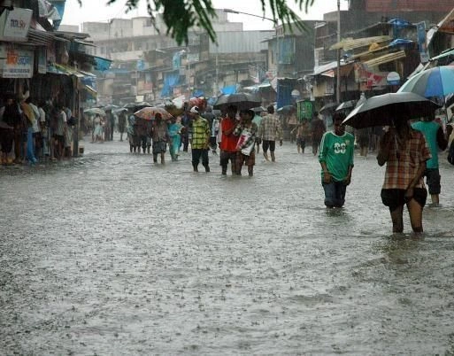
On April 4, Delhi had sporadic rains that raised the humidity to 80% and lowered the temperature to 22°C. The air quality got better for a short time, going from “poor” to “moderate” on the AQI scale. However, the roads were slippery, which led to little pile-ups. Farmers in Punjab and Haryana are worried about wheat crops that are still standing. “Rains at this stage can flatten the crop shortly before harvest,” says Baldev Singh, a wheat grower from Ludhiana. The IMD data backs this up: too much moisture can lead to rust fungal outbreaks, which might cut yields by 10–15%.
Uttarakhand had the worst time. Landslides blocked the Char Dham road, which made pilgrims going to Yamunotri late. Schools in Dehradun were closed for a day, and flights from Jolly Grant airport were rerouted. Since March 30, Uttarakhand’s disaster management chief has recorded more than 50 road obstructions.
This spring, Europe has been hit by comparable extratropical cyclones, with floods in Germany and snow in Spain. In India, the effects of ripples are part of bigger patterns. The IMD says this is because the polar vortex is getting weaker, which lets cold air move south. Timing is key for a country like India, where 60% of its acreage depends on rainfed agriculture. These disturbances bring important winter rain that fills up reservoirs like the Sutlej and Beas, but they can also cause problems if they happen at the wrong time.
Prediction: How Long Will the Unrest Last?
The most recent bulletin from IMD, which came out on April 6, doesn’t seem good. A new western disturbance will affect northwest India from midnight till April 9. Expect:
J&K, Ladakh, Himachal, and Uttarakhand will see moderate to heavy rain or snow until April 8.
On April 7 and 8, there will be light to moderate rain and thunderstorms in Punjab, Haryana, Delhi, Rajasthan, and western UP.
Isolated rains will reach Madhya Pradesh and Bihar on April 9.
In Himachal, 12 districts are on yellow alert, and in Uttarakhand, 8 districts are on yellow alert. Orange alerts mean that the risks are higher in the valleys of Kashmir, where temperatures might dip to 5°C. After April 10, there could be a little break, but ECMWF models say that another system is hiding in the Mediterranean.
Satellite images from INSAT-3D reveal a clear cyclonic circulation over Pakistan that is bringing in moisture from the Arabian Sea. This mix of a western disturbance and an easterly trough makes it more likely that it will rain. The Delhi center of the IMD said, “This season, we’ve seen 20–30% more rain than average.” In April, northwest India usually gets 15 to 20 mm of rain. Right now, some places are getting close to 40 mm.
Indian Railways has warned travelers that there will be delays on the Delhi-Chandigarh and Jammu routes. IndiGo and Air India say to check for diversions. In Pune and Mumbai, things like milder winds could make the nights nicer, but the main activity stays in the north.
Wider Effects: Farming, the Economy, and Daily Life
These problems go well beyond weather applications. Agriculture takes the most damage. Punjab’s wheat harvest, which is very important for India’s food security, covers 30 lakh hectares. Long periods of rain might delay threshing, which can lead to lower quality and rot after harvest. The government has used drones to look at crops, but farmers in Bathinda say their fields are full of water up to their knees.
Tourism hurts the economy. The tulip gardens in Srinagar, Kashmir, bloomed early this year and drew people, but snow has pushed back the peak season. Hotel proprietors in Manali anticipate a 40% decline in reservations. Conversely, Himachal’s hydropower plants are performing admirably, with reservoirs at 70% capacity, a boon for alleviating summer electricity shortages.
City dwellers are also feeling the impact. Power demand in Delhi surges when air conditioning units are shut off, while fog and rain create difficulties for commuters.
There were 10% more passengers using the Delhi Metro last week because people stopped using two-wheelers. Cities like Chandigarh are installing more smart drainage systems, which are paid for by the Smart Cities Mission. This is a sign of adaptation.
What does this indicate for India’s story about its climate? Western disturbances bring 30–40% of the winter rain to northwest India, which is important for rabi crops and groundwater. But these systems are changing as the world’s temperatures rise. 2025 was India’s warmest year on record. Research from IIT Delhi indicates a 15% increase in extreme weather events since the year 2000. This uptick is connected to the warming of the Arctic, which in turn is altering jet streams.
People’s Stories in the Storm
It’s not just numbers and warnings. Meera Devi, a shopkeeper in Kullu Valley, saw snow cover her roadside booth for the second time this season. “We pray for sun tomorrow; travelers add vitality to our hamlet,” she says. Rescuers in Uttarakhand saved a family from a house that had been struck by a landslide near Rishikesh. Their swift actions undoubtedly made a difference. These accounts serve as a stark reminder: weather isn’t some abstract idea; it has real-world consequences.
Consider, for a moment, how a hurricane brewing hundreds of miles away can still manage to drench your hometown. Such occurrences link us to global weather systems, prompting a desire for greater preparedness.
How to Deal with Risks: Advice and Government Action
First and foremost, safety. IMD says to stay inside during lightning, avoid traveling in the hills, and monitor river levels. Farmers should cover their crops with tarps and keep an eye on IMD’s Mausam app. Governments have stepped up: Himachal’s NDRF teams are ready to help, and Punjab is giving money to farmers who have been hurt.
India wants infrastructure that can last for a long time. The National Action Plan on Climate Change puts a lot of emphasis on early warning systems. IMD’s Doppler radars now cover 80% of the country. The Unified Meteorological Facility and other projects like it want to make forecasts more accurate.
What Will the Future Be Like?
Questions remain when this disturbance fades. Will the rain in April fill the summer reservoirs and stop water shortages in Delhi and other places? Or will they mean more trouble in a world that is getting warmer? Western disturbances show how weak India is—a country where the weather controls crops, holidays, and news.
For now, people in North India are staying warm and watching the sky. The IMD says it will keep us updated, but one thing is clear: these storms need to be taken seriously. As climate patterns change, adjusting isn’t an option; it’s a matter of life and death. remain safe and remain informed; the weather won’t wait for you.
Western Disturbances Hit North India: Unstable Weather Will Continue with Warnings of Rain, Snow, and Problems