
India’s space agency is about to reach another milestone at the quiet launchpad in Sriharikota. The Indian Space Research Organisation (ISRO) is getting ready to launch a next-generation navigation satellite that would make NavIC, India’s domestic GPS competitor, even better. It’s not just about getting better maps on your phone. It’s a big step toward being able to rely on yourself in a world where satellite technology affects everything from farming to war. With tensions rising in the area and the world becoming more dependent on foreign systems like America’s GPS, this launch seems like the right time. Why does India, which has a thriving digital economy, require its own constellation? The answer is accuracy, safety, and independence.
A Quick Review of How to Build NavIC from Scratch
NavIC, which stands for Navigation with Indian Constellation, started as a fantasy in the early 2000s. ISRO originally brought up the notion after the 1999 Kargil battle, when Pakistan blocked GPS signals and showed how weak they were. Today, NavIC has seven satellites in orbit that cover all of India and up to 1,500 kilometers outside its borders. That’s enough for precise placement within a few meters—like helping ambulances get through Mumbai traffic or helping fishermen spot tsunamis off the coast of Kerala.
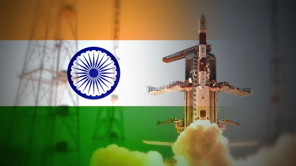
But there are limits to coverage. The technique works well in some areas but not so well over oceans or other places. The next generation bird is NVS-02, which is part of the Navigation with Indian Constellation series. This satellite is set to launch on a GSLV Mk II rocket, probably by mid-2026. It has improvements like dual-frequency L1 and L5 bands. That means clearer signals even in hard-to-reach places like cloudy skies or urban canyons. V. Narayanan, the head of ISRO, has hinted at better atomic clocks that will make timing rock-solid, which is important for keeping everything from stock exchanges to missile guidance in sync.
What makes this different? NVS-02 is different from older IRNSS satellites because it offers a lot of civilian apps. Think about how farmers in Punjab may use it to spray pesticides more accurately and save 20–30% on expenditures. Or disaster teams in Bihar, where floods have hit, finding people to save. India’s initiative here fits with its Digital India campaign, which will help over 1.4 billion people, many of whom have smartphones.
Tech Breakdown: What Is Inside?
Let’s cut through the technical talk. It’s similar to GPS, but designed specifically for our needs. Satellites beam down signals containing location data, and your device interprets this to pinpoint your position. The latest version is an improvement, offering real-time accuracy within a meter – a level that meets GPS III standards.
Tests from earlier NVS-01 revealed that inaccuracies were getting smaller to 1–2 meters in some areas. The L5 band cuts through buildings and bad weather easier, which is useful during India’s monsoon season. It also has rubidium atomic clocks that tick more reliably than cesium ones in older satellites. Civilian signals open up apps, and encrypted military signals can be used for both. For example, army tanks in Ladakh get unjammable navigation, and Ola drivers can avoid potholes.
ISRO isn’t the only one making new wheels. They’ve brought in commercial companies like Alpha Design Technologies to help with payloads. How much? About ₹250 crore each satellite, which is a good deal compared to GPS satellites that cost $200 million each. And guess what? Indigenous tech is now at 90%, which cuts down on import costs. Milestones tell the story: IRNSS-1A was the first satellite to launch in 2013; the whole seven-satellite constellation became active in 2018; NVS-01 added the eighth satellite with L1/L5 in 2023; and NVS-02 will shortly make it nine, moving toward full upgrades.
Why Now? Politics and Small Wins in Daily Life
The time is important. The US has GPS, which covers the whole world, whereas China’s BeiDou covers Asia. India has problems since it had to rely on them, including the GPS loss in 2012 during blackouts in the Northeast. NavIC changes that. In terms of military power, it’s gold: think of BrahMos missiles locking onto targets without support from other countries. The Indian Army is already testing NavIC receivers in drones along the LoC.
What about the civilian side? Potential for explosions. For example, India’s 140 million farmers waste billions of dollars because of inaccurate inputs. Tractors with NavIC could map fields meter by meter, which would increase yields by 15%. Companies that handle logistics, like Delhivery, are interested in it for last-mile delivery in remote areas where GPS doesn’t work well. For high-frequency trades, even stock exchanges like BSE-NSE need atomic-clock accuracy. NavIC provides that.
It’s a flex all over the world. Modi talks about NavIC in G20 meetings as a public good, like UPI for money. Partnerships are forming—Japan’s QZSS might mix signals to cover the Indo-Pacific. Apps are coming up in India. For example, MapmyIndia works with NavIC for Android, and Boat smartwatches advertise it. Have you ever wondered how your phone knows you’re right on the money at a hill station viewpoint? That’s NavIC slowly coming in.
Wins in the real world are already clear. NavIC notifications saved lives in Odisha during Cyclone Amphan in 2020. Fishermen applications let you know about areas where you can’t fish, and they do this through satellite pings. Economists say that NavIC’s GDP ripple will reach ₹1 lakh crore by 2030, including everything from fisheries to fintech.
Problems on the Launchpad: Things Aren’t Always Going Smoothly
There are always hurdles in the road for space races. NVS-01, which was launched in March 2023, ran across problems that cut its existence short. ISRO rushed to rectify things, but it showed that rubidium tech was still in its early stages. The GSLV Mk II is having problems with delays, and changes to the cryogenic engine are pushing back the schedule. Budget cuts hurt too—ISRO’s annual budget of ₹13,000 crore is up against moon missions like Chandrayaan-4.
People who are very concerned about security are worried about jamming. Enemies like Pakistan test anti-satellite tactics. NavIC’s military signals use anti-spoofing, but it’s important to scale processors down to phones. After COVID, there weren’t enough chips to make receivers work. ISRO is still putting receivers in phones that are made for the public market. You can expect to see them in Made-in-India phones by 2027.
From a human point of view, the 10,000 workers at Sriharikota sweat the small stuff. Under floodlights, technicians make small changes to solar panels. Vets conduct simulations for 72 hours. “It’s like getting a Diwali rocket ready that won’t fizzle,” one engineer said. These anecdotes show that tech is based on hard work and brains.
India’s Bigger Space Surge: Putting NavIC in Context
This launch fits inside ISRO’s busy schedule. Gaganyaan astronauts are getting ready for a crewed voyage in 2026. NISAR and NASA are mapping changes on Earth, while SPADEX is testing docking for space stations. Skyroot and Agnikul are two private companies who want to launch small satellites. This will make it easier to add more NavIC satellites.
In the world, GPS has 31 satellites, Galileo has 30, and BeiDou has 45. NavIC’s seven seem small, but its focus on specific areas is strong. In 2017, India launched 104 satellites in one go, setting a world record. NavIC makes that stronger.
People in Maharashtra, like those in Nashik, take it personally. Precision farming could change onion fields, and auto clusters in Pune are getting ready for NavIC-guided EVs. In India, it has to do with Atmanirbhar Bharat, which is about making your own technology in the middle of a US-China trade war.
What if NavIC became popular all over the world? Could it break up the GPS duopoly? It’s still early, but signs point to yes.