
The India Meteorological Department (IMD) has issued new warnings for rain, thunderstorms, and strong winds throughout many states in India. This means that the country is about to see another round of bad weather. The next few days will likely test how ready states are for weather that changes quickly, from dust storms in the north to heavy rain in the northeast and parts of peninsular India.
This most recent weather warning is not the first of its kind. It falls into a pattern that we’ve seen before: storms that come out of nowhere, rain and heat waves that aren’t normal for this time of year, and so on. It’s not just a forecast for millions of people anymore; it’s about their safety, crops, power outages, transport problems, and everyday life.
What the IMD Says Will Happen
The IMD’s most recent reports show that there is a large area of instability throughout north, central, east, and northeast India, with some activity in the south as well. The general indications are evident, even though the exact strength changes:
Parts of Uttar Pradesh, Rajasthan, Madhya Pradesh, Chhattisgarh, Bihar, Jharkhand, and West Bengal are expected to see thunderstorms and lightning.
Storms in the Indo-Gangetic plains can bring strong winds that can gust between 40 and 60 kmph.
Hailstorms can happen in small areas, especially on higher ground or at the edges of intense convective systems.
Parts of the northeast, such Assam, Meghalaya, Arunachal Pradesh, and Nagaland, are going to see a lot of rain.
States along the coast and in the south, such as Kerala, Karnataka, Tamil Nadu, and Andhra Pradesh, may see some rain and gloomy, humid weather.
In addition to this, the IMD has issued yellow and orange alerts for numerous areas, which means people should be careful and ready. Authorities have been told to be ready for tree falls, power outages, and damage to fragile buildings in some areas, especially those where strong winds and thunderstorms are expected.
Why This Weather Pattern Is Happening Right Now
Early April is a tricky time for India’s seasonal cycle to change. The southwest monsoon is still weeks away, even if winter is over. The country is affected by:
Western disturbances are migrating from the Mediterranean region to North India.
There are low-pressure bands or troughs forming over central and eastern India.
Winds from the Bay of Bengal and the Arabian Sea bring moisture to thunderstorms.
Land temperatures rising cause convective activity, which lifts warm, wet air up and feeds storms.
Meteorologists term this mix “pre-monsoon” activity. It includes dust storms, thunderstorms, squalls, and short but heavy rain. These systems can look as scattered yet strong cells on satellite photos, not a steady belt of rain.
The science underlying it could seem far away to most people. What matters more is the effect: how a clear, hot afternoon may quickly morph into a dark, windy, lightning-filled evening, with temperatures dropping quickly after a storm passes.
States on Alert: From the Plains to the Hills
This round of IMD advisories focuses on a few areas, each of which has its own set of concerns.
North India (Delhi-NCR, Uttar Pradesh, Haryana, Punjab, Rajasthan) is likely to get dust storms, thunderstorms, and strong winds. There could be brief but intense rain and hail in certain places.
Central India (Madhya Pradesh, Chhattisgarh, and parts of Maharashtra): Thunderstorms with lightning and strong gusts that could hurt crops and outdoor workers.
East and Northeast (Bihar, Jharkhand, West Bengal, Assam, Meghalaya, Arunachal Pradesh): Thunderstorms and heavy rain in some areas, which could cause floods and waterlogging.
South and Coastal (Kerala, coastal Karnataka, Andhra Pradesh, Tamil Nadu): There will be isolated to scattered showers and thunderstorms in the nights. Some roads will be slippery and the sea will be choppy in some places.
In several of these areas, local governments have begun sending out warnings through district authorities, police, and emergency management teams. People who might be on the road, in a field, or at an open construction site are getting IMD warnings through social media, SMS alerts, and TV updates.
What This Means for Farmers and People in Rural India
Weather alerts aren’t just notifications for Indian farmers; they can mean the difference between making money and losing money. Thunderstorms, strong winds, and hail can hurt crops that are still growing, especially during harvest time.
Many farmers in northern and central India are either harvesting or getting ready to harvest rabi crops at this time of year, such as:
Wheat
Mustard
Gram
Lentils
Wheat fields can be flattened by strong winds. Hail can hurt or kill grain heads. Rain that falls at the wrong time can boost the moisture levels in stored or harvested crops, which can impair their quality. That’s why it’s important to clearly and early share IMD forecasts with everyone.
The IMD and agricultural authorities typically tell farmers to:
Avoid harvesting and threshing while thunderstorms are at their worst, especially in the afternoon and evening.
Put harvested grain in safe places or under the right covers.
When lightning is likely, turn off the irrigation pumps and stay away from electric poles.
Don’t use tall machines or metal tools in wide fields while there is a lightning alert.
A two-day storm might cost rural families a lot of money for months if they only grow one crop cycle. There is a growing attempt to connect weather alerts with crop insurance plans and real-time apps that provide farmers advice. This shows how closely climate and livelihoods are now connected.
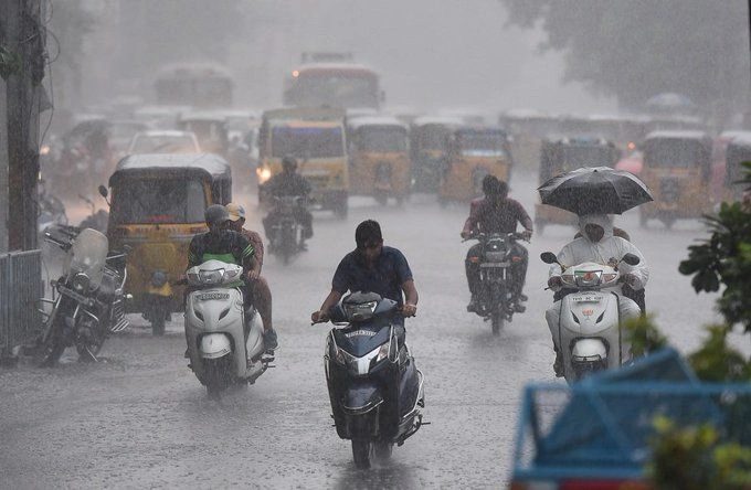
Power lines, traffic, and everyday life in cities
Cities are also getting weather warnings this time. Thunderstorms and squalls in cities don’t always happen the same way:
Roads and cars might be hit by falling trees and branches.
Windy weather puts stress on overhead electrical wires, which can cause power outages.
When it suddenly rains, traffic gets worse because of poor visibility and waterlogging in low-lying areas.
Hoardings that aren’t tied down, building materials, and temporary constructions can all be dangerous.
A 30-minute strong storm during rush hour might mess up the schedules of those living in big cities like Delhi, Lucknow, Kolkata, Bengaluru, or Guwahati. Public transportation is slower, planes may be delayed, and outdoor events or markets may be stopped without warning.
This is where being ready at the city level on time is important. Some cities have started:
Cutting back old and fragile trees before the storm season reaches its peak.
Checking electric poles and wires in areas that are easy to get to.
Cleaning out drains and culverts that are notorious to get clogged.
Giving people warnings not to park under trees or damaged structures while it’s rainy.
As people get used to intense heat and heavy rain warnings during the monsoon, are we adapting rapidly enough to this time of year when storms come and go swiftly, leaving behind a lot of small but broad damage?
Weather extremes are getting worse, and the climate is changing.
The fact that weather advisories are happening more often in India makes me wonder: are these just normal seasonal changes, or is something greater happening behind the scenes?
Scientists who study climate have known for a long time that a warmer atmosphere can contain more water, which can make storms stronger when they do happen. In the last few years, India has seen a number of trends:
More strong rainstorms that last a short time in several places.
Heat waves that last longer and are hotter before the monsoon.
Changes in when and where monsoon rains fall.
More frequent, localized, extreme weather events like cloudbursts and heavy thunderstorms.
Not every storm or rainfall occurrence can be directly linked to climate change, but the overall trend of instability is hard to ignore. As extreme weather becomes more common, policy documents, including India’s own climate action and adaptation plans, now clearly say that early warning systems and local resilience need to be improved.
One part of this adaption narrative is how the IMD is using more color-coded alerts, district-level predictions, and impact-based advisories. The other aspect is how states, cities, and communities react and plan for the future.
How to Stay Safe When There Is Thunderstorm
With the IMD warnings, it is just as vital for individuals to be ready as it is for institutions to respond. During storms and severe winds, certain basic things can make a big difference in how safe you are:
When thunderclouds start to form, stay inside. Stay away from wide fields, roofs, and big trees that are alone.
If there is a chance of severe lightning, unplug any electrical devices that aren’t necessary.
Don’t use wired phones or stand near metal windows when there is a lot of lightning.
Don’t take cover behind a single tree or near a pole, especially in open regions.
If you’re driving, slow down, keep your headlights on, and stay a safe distance away. If visibility reduces suddenly, pull over safely.
If you ride a two-wheeler, don’t try to flee a storm. Instead, find a safe place to stay.
People who live near the coast or fish often get advice to keep a close eye on IMD bulletins, especially when there are warnings for squally winds or strong seas. For them, determining whether to go out can mean the difference between life and death, not just a hassle.
Looking Ahead: From Warnings to Strength
The rain, storms, and strong winds that are currently affecting numerous Indian states are likely to last for several days, with the intensity rising and declining as systems move and diminish. Before the main monsoon arrives, we might expect more of these periods.
The problem going forward is not merely to send out timely notifications, but also to make them part of people’s daily lives:
Farmers are making their sowing, harvesting, and storing more in line with reliable projections.
Cities are putting money into tree care, drainage, and strong power lines.
Schools and businesses are putting simple weather safety rules in their calendars.
Media outlets provide space not just to stunning pictures, but also to useful safety tips.
The weather in India will always be different and sometimes bad. The rapidity and unpredictability with which things go from one extreme to the other is what is changing. As IMD warnings about rain, storms, and severe winds become more common in several regions, the country is being pushed toward an important question: can we turn this expanding flow of weather information into everyday resilience instead of just reacting at the last minute?
As clouds accumulate in different parts of the country, the best thing to do right now is to stay aware, take alerts seriously, and see every thunderstorm as a cue to stop, get ready, and protect yourself.