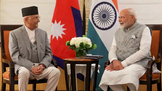
India’s firm rejection of Nepal’s latest objections over the Lipulekh‑Kalapani stretch has thrust the two neighbours back into a long‑simmering argument over maps, memories, and miles of Himalayan road. At the heart of this latest row is not just a few square kilometres of high‑altitude territory, but something bigger: how India and Nepal see each other’s sovereignty, their strategic interests, and the role of China along their shared Himalayan frontier. With India gearing up to resume trade through the Lipulekh Pass this year and Kathmandu loudly insisting that the area belongs to it, the question on everyone’s mind is whether this dispute can be de‑escalated—or whether it will quietly harden into a permanent fault line in Indo‑Nepal relations.
What exactly is India rejecting?
India’s latest position is that Nepal’s objections to its use of the Lipulekh corridor and surrounding Kalapani area are “untenable” and not grounded in historical or legal fact. New Delhi points to more than sixty years of continuous administrative and military control of the area, including the maintenance of security posts and the operation of traditional trade routes through the pass long before any recent Nepal–China tensions. Officials argue that bilateral India–China understandings about reviving border trade through Lipulekh are fully within their sovereign rights and do not require Nepal’s consent over territory India administers.
In practical terms, India is rejecting three main Nepali demands:
That bilateral India–China decisions on Lipulekh be treated as “invalid” without Nepal’s prior agreement.
That Nepal’s constitutional map, which enlarges the country’s territory to include Kalapani, Limpiyadhura, and Lipulekh, be treated as binding.
That India halt road‑building and infrastructure work in the tri‑junction area until the boundary dispute is formally settled.
From Kathmandu’s standpoint, rejecting these demands feels like a slap at national pride; from New Delhi’s, they are seen as attempts to overturn a long‑established status quo.
Why Lipulekh matters so much
Lipulekh is not just another high‑altitude pass; it is a strategic gateway that sits at the India–China–Nepal tri‑junction in western Uttarakhand. For India, the pass is a key part of its Himalayan border‑trade network with China, and its new road network up to the pass strengthens both military mobility and logistical access to remote border areas. The route also matters for India’s broader connectivity ambitions in South Asia and the wider Indo‑Pacific, where land links with China and the wider Eurasian market are increasingly important even as political tensions run high.
For Nepal, Lipulekh’s importance is more symbolic and emotional. The area is widely perceived as part of historic Nepali territory defined by the 1816 Treaty of Sugauli, which fixed the Kali River as the boundary between the two countries. Kathmandu argues that the river’s source lies further upstream at Limpiyadhura, thereby placing Kalapani and Lipulekh on its side of the line. When India and China talk only to each other about reopening trade through Lipulekh, it feels to many in Nepal as if the two giants are making decisions over territory that Nepal itself claims—and that unsettles a small, land‑locked country already wary of being squeezed between its massive neighbours.
The map, the river, and the contested origin
The core of the dispute is deceptively simple: where does the Kali River actually begin?
Nepal’s position is anchored in the Sugauli Treaty and certain British‑era maps that show the river’s source at Limpiyadhura. Such an interpretation would move the boundary line further west and place Kalapani, Limpiyadhura and Lipulekh within the sovereign jurisdiction of Nepal. Nepal has accordingly drawn new official maps and incorporated these areas into its constitution, turning the dispute into a matter of domestic politics as well as international law.
But India insists that the river’s true source is nearer to the Kalapani village, which has been under Indian control since the 1960s. Indian officials say their claim is based on historical usage, such as the deployment of Indian security forces and the upkeep of border posts. They also point out that the row has never been formally resolved by a joint boundary commission, so unilateral map changes by either side do not automatically change the legal reality on the ground.
On the ground, this disagreement over a map symbol and a river’s source translates into competition over infrastructure. India’s decision to build a road right up to the Lipulekh Pass has been seen by many in Nepal as an attempt to “concretize” the status quo, while India insists it is merely improving its own connectivity and defence preparedness. In a region where physical presence often precedes legal settlements, every kilometre of road potentially becomes a statement of sovereignty.
Road connectivity and the strategic angle
India’s investment in road connectivity in the Himalayas is not just about faster movement of troops; it is also about economic resilience and regional influence. The road network to Lipulekh strengthens India’s ability to respond quickly to any flare‑up on the China border, but it also creates a smoother logistics corridor for border trade in the longer term. For a country that has faced disruptions in eastern trade routes and a tense border with China, access to alternative Himalayan corridors is a matter of strategic insurance.
For Nepal, the same roads are read through a different lens. Kathmandu has long worried that India’s infrastructure projects in the border region—ranging from check‑posts to feeder roads—could be used to project economic and political influence inside Nepal. Some analysts openly ask whether India’s connectivity push is more about “soft power” than pure border security. One might wonder: when a big neighbour builds a highway that stops just short of your claimed territory, is it meant to reassure you—or to remind you who holds the upper hand?
India points out that it has also funded several road and bridge projects inside Nepal, from the Terai roads to border‑crossing infrastructure, as part of its broader development‑assistance strategy. These projects are meant to ease trade, reduce transit time, and integrate Nepal more closely into India’s economic orbit. Yet, the irony is that even while India invests heavily in Nepal’s internal connectivity, fresh tensions over a few square kilometres of territory in the Himalayas threaten to overshadow the larger picture of cooperation.
Why Nepal feels sidelined
Nepal’s latest objection is not just about territory; it is also about process and dignity. When Indian and Chinese officials announced the resumption of border trade through Lipulekh—with no prior consultation with Kathmandu—many in Nepal interpreted it as a classic example of big‑power politics. The perception is that India and China can make decisions affecting Nepali‑claimed territory without even inviting Nepal to the room.
For a country that has long prided itself on a “neither India nor China” policy, this feels like a subtle erosion of agency. Nepal has periodically protested similar moves, including in 2015 and 2020, when India’s road construction and border‑trade talks first drew strong objections. Yet, each time, the diplomatic cadence has been similar: a loud statement from Kathmandu, a calm rebuttal from New Delhi, and then a slow return to a fragile, uneasy quiet.
This pattern raises a deeper question: can a small country truly negotiate as an equal when the two sides of the table are the world’s largest democracies and one of the world’s most powerful economies? For Nepali policymakers, the Lipulekh issue is as much about how their neighbourhood is reshaped as it is about the exact coordinates of a mountain pass.
Public sentiment and nationalism on both sides
In India, the official stance has been accompanied by a more muted public conversation. In the Himalayan border districts, communities that have lived with the Kalapani–Lipulekh issue for decades tend to see the area as part of their own homeland, and they support the state’s efforts to secure the border and improve connectivity. At the national level, however, the dispute has not become a major electoral or media flashpoint in the way that some other India–China border issues have; it is seen more as a technical and diplomatic matter than a crisis.
In Nepal, the opposite is closer to the truth. Kalapani and Lipulekh have become emotional touchstones in national discourse, often invoked in political speeches and media debates. Maps with the enlarged territory are printed in textbooks and displayed in government offices, turning a cartographic disagreement into a matter of national identity. Social‑media campaigns regularly resurface calls for “reclaiming” the territory, and even opposition parties line up behind the government’s stance, at least in public.
Nationalism on both sides risks hardening positions and making compromise harder. If every mention of the border is treated as a test of sovereignty, then even technically routine issues—such as road‑building or trade‑route management—can spiral into diplomatic standoffs. That is why the way this issue is framed in the media and in political rhetoric matters as much as the underline facts.
India Stands Firm on Lipulekh, as Nepal’s Border Protest Sparks New Friction