A 7.4-magnitude earthquake hit Indonesia’s Molucca Sea region on April 2, 2026, causing short-lived tsunami worries and leaving populations to pick up the pieces. The catastrophe, which took place near Ternate Island, put the country’s disaster response capabilities to the test and showed that one of the world’s most earthquake-prone areas is still not safe. As the aftershocks diminish and things return to normal, the focus switches to what this implies for future preparedness, especially because seismic concerns are growing around the world.
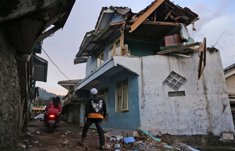
The yellow tape around the fallen structure in the picture, which is surrounded by scattered wreckage, offers a story of how fragile things are when nature strikes. People and officials are going through the damage in North Sulawesi.
Latest News from the Ground
By April 3, 2026, there had been one death: a 70-year-old lady who was killed when rubble fell on her in Manado. There had also been a few injuries, largely from people who were scared and had to leave quickly. Damage reports showed that hundreds of residences had broken walls, a church spire had fallen in Ternate, and power outages had occurred all over North Maluku and Sulawesi. Aftershocks, which reached a maximum of 5.2, have calmed down to minor rumbles, letting some people go home, while many would rather stay in tents in open fields.
The BNPB disaster agency in Indonesia said that there were no severe infrastructure failures, such bridges falling down, because of recent repairs. Quickly, relief efforts got bigger. Basarnas sent food packages, water tanks, and medical personnel to isolated areas by boat and helicopter. Tsunami waves reached a maximum height of 75 cm and caused some beach damage, but no one drowned because people were evacuated quickly. Still, the surges seized gear from fishermen in West Halmahera, and tourists kept away from Ternate, which smelled like spices.
How Warnings Made the Day Better
The BMKG’s InaTEWS system worked again. Within minutes, SMS, apps, and village sirens sent out alerts telling people on the coast to move to higher ground. As traders grabbed booths and ran, markets in Bitung emptied. Schools in Manado drilled pupils directly into action. The U.S. Tsunami Warning Center backed it up, but BMKG said all was fine at 9 a.m. after buoys showed minimal waves.
This wasn’t the nightmare of 2004, when 167,000 people died in Indonesia because there was no system to help them. Drills are now a normal part of life, and apps like InaRISK can show you the hazards in your area. But there are still gaps in rural areas: some islands received delayed signals, which made elders apprehensive. A shopkeeper in Ternate told reporters that at first he didn’t answer his phone because he thought it was a prank. Then the ground shook.
Indonesia’s Ring of Fire: A Never-Ending Dance with Danger
Ring of Fire in the Pacific
Indonesia never gets a break. It sits on the Pacific Ring of Fire, where five tectonic plates meet, and it has more earthquakes than anywhere else—over 7,000 a year. The Molucca Sea is above the Halmahera trench, where the Pacific plate grinds against other plates, which causes tension that leads to things like this. History is cruel: the 2018 Sulawesi tsunami-tsunami combo killed 4,300 people. Despite warnings, the Cianjur inland tremor killed 600 people.
By local standards, this 7.4 was “mild.” It was just 35 km deep, but it was far from significant cities. Experts look at aftershock clusters to see if there are bigger rifts nearby, like in Papua or Seram. Climate changes things: higher waters could make future tsunamis stronger, hitting low-lying atolls harder.
The Ring of Fire map shows the flaming arc from New Zealand to Japan, with red areas showing subduction zones. Indonesia’s part is full with volcanoes and earthquake faults. It’s not hard to see why it’s called the “Ring of Fire.”
Preparedness: What Worked and What Didn’t
Changes made after 2004 changed the way Indonesia played. InaTEWS connects 400 seismic stations and ocean buoys to worldwide networks. BNPB trains millions of people through gamified applications and village squads. Since 2015, building standards in Sulawesi require deeper foundations to protect against earthquakes. There are also 1,200 early-warning sirens along the beaches.
Here are some quick facts about the upgrades:
Monitoring boost: There are now three times as many sensors as there were in 2010, and AI can now estimate wave heights.
Community reach: 80% of high-risk villages have teams ready to help.
5,000 schools were retrofitted, and highways were made quake-proof for more than 4,000 km.
Tech edge: Free apps send individualized alerts in the local language.
But Cianjur showed that there are blind spots inland—no tsunamis there, but rescues took a long time because of bad planning. Maluku is behind on funding, and urban growth is outpacing codes. One issue keeps coming up: Are cities like Manado really strong, or did they just get lucky this time?
Echoes in India and other places
India, notably the Andaman and Nicobar Islands, is still shaken by Indonesia’s close call. They share the same Sunda megathrust that caused the horrors of 2004. Nagpur may seem far away, but seismic Zone V puts the Andamans at high risk. Recent swarms there are similar to those in Molucca. India’s NISDR and ASEAN do drills together, and India is interested in using InaTEWS technology for their own buoys.
The seismic forecast for 2026 is not good: GEM’s new hazard maps show urban liquefaction hotspots from Tokyo to Chile. The World Economic Forum (WEF) says that geophysical disasters are the most dangerous things that may happen, and they are getting worse because of floods caused by global warming. Philippines quickly raised its alerts but lost boats; Malaysia got ports ready. Shared oceans need shared watchfulness. Could apps that work across borders be next?
Indonesia’s model teaches Indian coastal cities like Chennai and Mumbai to drill often, signal everywhere, and build smart. Have you ever considered about putting together your own earthquake kit including water, a radio, and strong shoes?
Making a Safer Path Forward
Engineers are checking bridges, psychologists are helping those who are shaken up, and insurance companies are counting claims. President Prabowo’s administration promised more money for rebuilding in Maluku, with a focus on anti-liquefaction pilings. Schools are back in session with trauma sessions, while the marketplaces in Bitung are busy again.
This earthquake shows that things are getting better—no mass fear, waves were limited, and life was low. One setback, however, is a sharp reminder: resting on your laurels can be fatal. Indonesia is making strides, adding more buoys, creating AI-powered earthquake predictions, and building sustainable homes that marry old-world methods with contemporary design. A call for global cooperation is in motion, with India, ASEAN, and Pacific Rim nations pooling their data. The aim?
To fortify against the destructive potential of the Ring of Fire.
Nature won’t stop moving. The true victory? Communities that bounce back smarter, faster, and united. The spice winds are stirring once more in Ternate, and with them, a renewed spirit of resilience emerges from the past.
One week after the earthquake in Indonesia, there are still questions about how safe it is to live there.